Good morning. Most of Houston is experiencing temperatures in the upper 60s to lower 70s this morning, with modestly lower dewpoints. This is not exactly fall-like weather, but it’s a reminder that we’re much closer to fall than you might realize. Moreover, there’s another weak front on tap in a day or so to keep our “September-pleasant” weather in place for the rest of the week.
Wednesday
Today will be hot, as drier air allows the air to warm quickly into the low- to- mid 90s under sunny skies. Light northerly winds will shift to come from the east later today, and eventually the southeast. This will herald the return of somewhat muggier conditions later tonight as the first weak front washes out. As a result low temperatures Wednesday night may be a few degrees warmer than Tuesday night.

Thursday and Friday
Another weak front will be on the move Thursday, however, and it should reach the coast by around noon or shortly thereafter. This one should have even a little bit more drier air with it. So while highs on Thursday will warm into the mid-90s beneath sunny skies, lows Thursday night should drop to around 70 in the city, with cooler temperatures in outlying areas. It will be nice. Expect similar conditions for Friday, which should see the driest air of the week.
Saturday
The drier air should hold into Saturday before our air mass becomes modified by the onshore flow. Still, I’m expecting mostly sunny skies for the first half of the weekend, with highs in the low- to mid-90s. Saturday night should be warmer and muggier.
Sunday and beyond
The party ends on Sunday as notably higher dewpoints in the mid- to upper-70s return to the region. Along with this we’ll see an abrupt shift in cloud cover and increasing rain chances. We still don’t have a great handle on rainfall amounts, but daily chances should be about 50 percent beginning on Sunday, continuing through much of next week. Highs will be around 90 degrees each day, with lows in the mid-70s.
Tropics
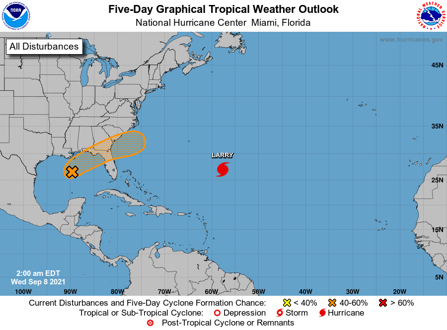
In the tropics we’re still tracking Hurricane Larry, which will avoid Bermuda and should gradually weaken as it lifts to the north. Closer to home, in the Gulf of Mexico, Invest 91L is moving toward the Florida Panhandle, where it has a 50 percent chance of becoming a tropical depression or storm before landfall. Regardless, it will make for a wet few days in Florida. Finally, we’re continuing to see the potential for a weak tropical system to develop in the Bay of Campeche late this weekend. However there is no real signal in the forecast models that this system will either develop further or move that much northward. Still, its moisture could play a role in our rainfall next week.

"front" - Google News
September 08, 2021 at 07:02PM
https://ift.tt/3hdr1P2
A second weak front will keep the dry air party going into Saturday - spacecityweather.com
"front" - Google News
https://ift.tt/3aZh1mr
https://ift.tt/3b2xvu5


No comments:
Post a Comment