ITHACA, N.Y. -- You can put away the garden hose this week, as a stalled front and a pair of storm systems result in a fairly wet and gray week ahead. If it's any consolation, it looks like Tompkins County will generally be on the warm side of that stalled front, with temperatures in the 70s for the next few days before a storm system ushers in cooler air and highs in the upper 50s and low 60s for the end of the week.


Your Weekly Weather
The primary influence on the local weather for the next few days is going to be a frontal boundary associated with a large storm system currently centered over the Great Plains. The problem for us is, the frontal boundary is running into a fairly impassive high pressure system to the north, and there's also a high over the southeastern United States, so it's stalling out; after passing through Tompkins County heading northward last night, it's hit the wall of high pressure to the north and shifting back south a little bit, though with that other high pressure, it's kinda just stuck until the parent low makes its way eastward. In the meanwhile, that frontal boundary is like a channel for propagating short waves, pulses of atmospheric instability that create cloudiness and rain, though nothing major.
YOUR LOCAL WEATHER NEWS IS MADE POSSIBLE WITH SUPPORT FROM:
With that frontal boundaries over upstate, there's a fairly wide range in high temperatures for today, from mid 50s in Oswego to mid 70s in Elmira. Even in Tompkins County, there's a noticeable range with warmer temperatures to the south and west. Highs will be in the mid to upper 60s in Groton and Dryden, and in the to low to mid 70s in Ithaca, Newfield and Danby, helped along by a later arrival of significant cloud cover as that frontal boundary sags southward. The more north and east you are, the earlier the cloudcover sets in and the more likely you'll see some rain showers this afternoon as that front slowly presses into the Finger Lakes. Ithaca should be partly to mostly cloudy through about 2 PM, and then mostly cloudy to overcast afterward. Even for those places that see rain this afternoon and evening, new precipitation amounts will be light, less than a tenth of an inch. The front will edge back northward overnight Sunday, and that will allow for some partial clearing, showers moving back north, and lows in the low to mid 50s.
Monday sees that front shift back south as well as a short wave enter the Southern Tier from the Ohio River Valley, and you'll want an umbrella. The morning will be mostly dry but with increasing clouds, and by noon it'll be near overcast, and scattered rain showers will build across the region from west to east. During the daylight hours, these will be light, with less than a tenth of an inch of rain. But expect to see a few raindrops from 2 PM on, and more like rain from noon on for readers west of Ithaca, with highs in the low 70s. The rain will be a little more persistent in the evening Monday, and a few weak thunderstorms are possible after sunset, feeding off that remnant daytime heating. The rain showers will persist through the night, but become more sporadic from midnight on. Outside of the rain, expect cloudy skies and lows in the upper 50s. New rainfall amounts Monday night will be between one-tenth and one-quarter of an inch.
Tuesday will once again offer a morning reprieve with mostly cloudy skies and isolated showers, but as the front takes on a more southwesterly angle, that will allow warmer air with more moisture into the Southern Tier. Highs will be in the mid 70s with mostly cloudy skies, but that heat energy and that instability of the front will fire off scattered showers and thunderstorms, especially during the afternoon and evening. The parent low swings through Michigan later Tuesday and into Canada, and this will usher in a large, moist, unstable air mass overnight, with frequent rain and numerous thunderstorms through Tuesday night and into Wednesday morning. Lows will be in the upper 50s, with new rainfall amounts around one-quarter of an inch.
ADVERTISEMENT
The stalled front lifts out Wednesday but a cold front swing through with the passage of the storm system northeastward. This will pass during the 8-11 AM period, and winds will turn from the southwest to the northwest. Frequent light rain showers in the morning will become less numerous during the afternoon as the system moves away, but with cooler air entering, highs will hardly rise from morning lows, topping out around 60°F and in the low 60s by sunset as skies begin to clear. Skies will continue to clear Wednesday night, with a few passing clouds by morning and lows in the lower 40s.
Thursday looks like the only truly dry day of the week as high pressure briefly builds in. Highs will be around 60°F with partly cloudy skies and breezy northwest winds. Thursday night will be partly to mostly cloudy but dry with lows in the low 40s, and maybe some upper 30s on the hilltops.
Friday will be more unsettled thanks to a developing coastal low moving from the Carolinas to the northeast towards Cape Cod. This storm system may create enough regional instability as it grows and strengthens to trigger some scattered rain showers in Tompkins County, with better chances south and east of Ithaca. Otherwise, plan for partly cloudy skies and highs in the upper 50s. Friday night will see that risk for showers persist and a few more clouds build in from the cloud shield of that low, resulting in mostly cloudy skies and lows in the low 40s.
The weekend is also looking unsettled, unfortunately. Saturday will see some lingering rain showers, perhaps of the lake-enhanced variety, with highs in the mid 50s thanks to that coastal low's counterclockwise circulation pulling down some cooler Canadian air, and overnight lows around 40°F (for what it's worth, any snow should stay well to the north and east). Sunday is looking warmer with temperatures in the 60s, but a new shortwave is likely to enter the region, resulting in scattered rain showers for your Mother's Day brunches.
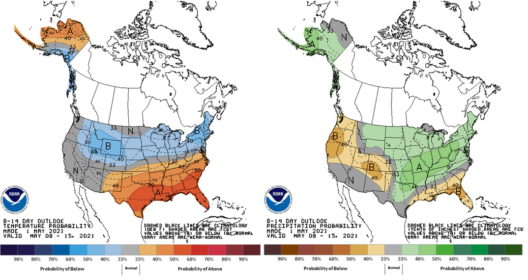
Graphics courtesy of the NOAA Climate Prediction Center.
ADVERTISEMENT
Extended Outlook
The medium-range outlook for mid-May isn't great. A strongly zonal pattern will result in cooler than normal conditions across much of the northern third of the continental United States, and when it's not fully zonal, the jet stream will take on a more southwesterly-northeasterly alignment that will likely tap into moisture from the Western Gulf of Mexico, increasing chances for above-normal precipitation. Just be glad it's May and not January, folks.
"front" - Google News
May 03, 2021 at 12:39AM
https://ift.tt/3beXvpd
Weather: Stalled front means a wet if mild week ahead - The Ithaca Voice
"front" - Google News
https://ift.tt/3aZh1mr
https://ift.tt/3b2xvu5


No comments:
Post a Comment