Another cold front will pass by over the weekend. Fortunately, it looks as though most of the daylight hours will be dry.
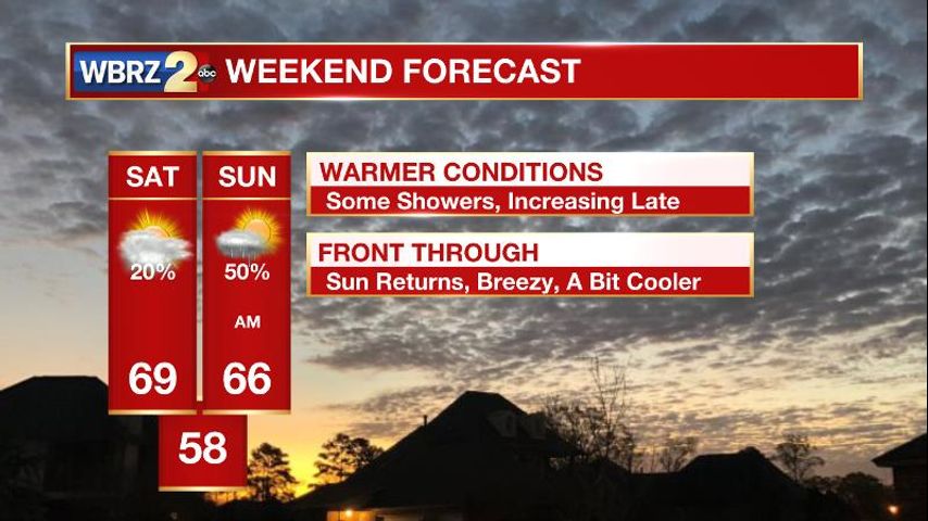
The Next 24 Hours: Overnight, temperatures will stay up a few degrees compared to the last few mornings as winds turn around to come out of the south. With a few clouds working in, expect a low in the mid 40s. A warm front will start to lift into the region on Saturday with increasing clouds and south winds pushing temperatures even higher. A run at 70 degrees is possible in the afternoon. A stray shower or two could develop in the Gulf air mass, but nothing organized is anticipated.
After That: The associated cold front and a broken line of showers will push through the area Saturday night and before dawn Sunday morning. Skies should clear quickly behind this front, so given the timing expected as of now, most of the daylight hours this weekend should be dry. Much of early next week will be quiet before we monitor a more impressive storm system for Thursday and Friday. More interesting than a few days with rain chances may be if whether or not a very cold air mass behind it can make it all the way to the Gulf Coast. CLICK HERE to view your complete 7-Day Forecast.
The Explanation: An upper level ridge will warm the atmosphere and cause some compressional warming Saturday in advance of the next frontal system. The associated upper level trough will invigorate a strong surface low over the Lower Midwest on Saturday. This low will help to pull a warm front north and cause southerly winds to bolster thermometers on Saturday afternoon. Moisture advancing inland could even churn up a spotty shower, but nothing widespread or organized is expected. The associated cold front will push through on Saturday night or Sunday morning with 50 to 80 percent rain coverage expected due to scattered showers. The upper low and surface low will move well north of the local area so the parameters are not supportive of severe weather, and possibly not even any thunderstorms. The storm system will push east of the area on Sunday ending rain chances from west to east during the morning hours. Sun and cooler temperatures will follow to end the weekend. Surface high pressure and northwesterly winds aloft will maintain cool and dry conditions through Tuesday. A large, longwave trough will dig into the Southwest by the middle of next week. Moisture will feed from southwest to northeast across the central Gulf Coast setting up a period of rain toward the end of next week. The trough will open up into a positive tilt and slow down which means there are no immediate alarms for severe weather. A much colder air mass is expected to follow that system into the Eastern U.S. It is still unclear if that very cold air will be shunted to our northeast or settle across the Gulf Coast.
--Josh
The WBRZ Weather Team is here for you, on every platform. Your weather updates can be found on News 2, wbrz.com, and the WBRZ WX App on your Apple or Android device. Follow WBRZ Weather on Facebook and Twitter for even more weather updates while you are on the go.
"front" - Google News
January 30, 2021 at 06:49AM
https://ift.tt/39vIGOn
Another cold front this weekend - WBRZ
"front" - Google News
https://ift.tt/3aZh1mr
https://ift.tt/3b2xvu5


No comments:
Post a Comment