- A significant snowfall is likely early this week in parts of the Rockies and Front Range.
- Parts of the Interstate 25 corridor, including Denver and Cheyenne, Wyoming, will see accumulating snow.
- The snowfall could be damaging to trees and might trigger power outages.
- This will be one of the earliest snowfalls on record in some Front Range cities.
- This abrupt change will occur just days after record-breaking heat.
An unusually early September snowstorm will blanket the Rockies and Front Range through Wednesday from Montana to northern New Mexico, including Denver, followed by an abrupt change to widespread record cold through the Plains following searing record heat this past weekend.
A deep southward plunge of the jet stream will bring in a sharp drop in temperatures to the Rockies and Plains over the next few days. There will be a disturbance diving through that jet stream, which will allow snowfall or a mix of rain and snow to spread southward through the Rockies and Front Range now through Wednesday.
That front has already plunged out of Canada into the northern Rockies, changing precipitation to snow in Glacier National Park and along the Rocky Mountain Front. This lead to the bizarre sight of fire and smoke in southwest Montana, and snow in northern Montana on Labor Day morning.
(CURRENT MAPS: Temperatures | Radar)
The National Weather Service has issued the winter weather alerts in the map below for this early-season snowfall, including winter storm warnings and winter weather advisories, from the Canadian border with Montana to the high country of northern New Mexico.
These winter alerts include the entire Denver metro area, Cheyenne and Casper, Wyoming.
Winter Weather Alerts
(From the National Weather Service.)Timing the Snowfall
Through Monday Night
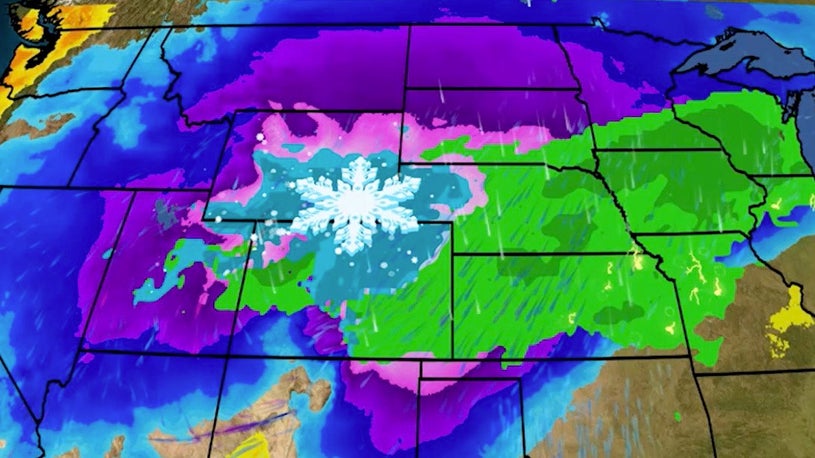
Snowfall or a mix of rain and snow will begin in the northern Rockies on Monday. By Monday night, snow or a mix of rain and snow will expand southward into much of Wyoming, northern Colorado, western South Dakota and western Nebraska. This precipitation will arrive with rapidly dropping temperatures and gusty winds.
Monday Night - Tuesday Morning Forecast
(The green shadings depict where rain is expected. Areas that are shaded blue are expected to see snow. Purple-shaded locations may see either rain or snow. Temperatures shown will occur Tuesday morning. )Tuesday-Tuesday Night
Snow or a mix of rain and snow will continue from southern Wyoming into western Nebraska, much of Colorado and northern New Mexico. Some light snow may linger Wednesday in parts of eastern and southern Colorado into northern New Mexico.
Tuesday Forecast
(The green shadings depict where rain is expected. Areas that are shaded blue are expected to see snow. Purple-shaded locations may see either rain or snow. Temperatures shown will occur Tuesday morning. )Snowfall Forecast and Impacts
You can see in the map below the areas from Montana to Colorado and northern New Mexico that could see at least some accumulating snowfall, through Wednesday.
Snowfall is expected on the Interstate 25 urban corridor, including Cheyenne, Denver and Colorado Springs. The snow in Denver would be just days after the city hit an all-time September record high of 101 degrees on Saturday.
Snowfall in the Denver metro area will be most likely on grassy areas, vegetation, vehicle tops and roofs.
Given it's still early September, many trees still have their foliage in Colorado and in neighboring states. The heavy, wet snow on this vegetation could result in tree damage and power outages in some areas.
Snowfall Forecast
(This the latest snowfall forecast, however, changes are possible.)One challenge in this forecast is how fast the cold air and snow will be able to overtake the very warm ground following highs in the 90s and low 100s.
Rapid City, South Dakota, currently holds the record for the shortest time span (5 days in September 2000) between a 100-degree temperature and measurable snowfall for major climate stations in the U.S., according to climatologist Brian Brettschneider. Denver has a good chance to break this record assuming measurable snow falls on Tuesday.
Given this, snow will melt on roads at least initially. In higher elevations, though, slushy snow will eventually accumulate on roads, leading to slippery travel. This could include stretches of Interstate 80 in Wyoming, Interstate 70 west of downtown Denver into the mountains, and Interstate 25 in Wyoming, Colorado and northern New Mexico.
Record Early Snow?
While the first three weeks of September are still officially summer, there are several locations in the U.S. where September snow occurs just often enough to not be considered a freak event.
Most of these locations are in the mountains, but not all of them.
We scoured National Weather Service 30-year average snowfall data to find first-order observing stations which average at least 0.1 inch of snow in September, including parts of New England, the Great Lakes, Plains and West. You can see these locations plotted in the map below.
Locations averaging at least 0.1 inch of snow in September, based on 1981-2010 averages from NOAA/NCDC.
Other locations have picked up September snow, but just not frequently enough to register a 30-year average of greater than a trace.
It is no surprise that many locations of the Rockies have often experienced snow in September. Some locations in western Montana and central Colorado see the first measurable snow on average in September.
Just last year, Great Falls, Montana, picked up over 19 inches of snow as September came to a close.
And snow is considered average in September along the Front Range from eastern Wyoming into eastern Colorado.
However, this could still be one of the record earliest measurable snowfalls in these Front Range cities.
Both Casper and Cheyenne, Wyoming, had their earliest measurable snowfalls - at least 0.1 inch - on September 8 in 1962 and 1929, respectively. Cheyenne's record earliest one-inch-plus snowfall set while William McKinley was President - September 10, 1898 - is likely to be shattered.
This won't be the record earliest snow in Denver. That happened on September 3, 1961, when 4.2 inches of snow fell in the city.
The last time snow fell in Denver in September was almost 26 years ago, on September 21, 1994.
Record Cold, Too
You can forget the blistering summer heat for awhile in the Rockies and adjacent Plains.
Dozens of daily cold records for early September will be shattered through Thursday.
Daytime "high" temperatures, if you want to call them that, will be 25 to 45 degrees colder than early-September averages from the Rockies into the Northern Plains and south into the High Plains of Texas and New Mexico through Thursday.
This means afternoon temperatures will be stuck in the 30s or low 40s at best in parts of Wyoming and Colorado and in the 40s or 50s in the Upper Midwest Tuesday and Wednesday. Parts of western Texas may not rise out of the 50s or 60s during the day, either.
(MAPS: 10-Day U.S. Forecast Highs and Lows)
Morning lows will plunge into the 20s down the Front Range from Montana to northern New Mexico. Thirties are forecast from the Texas Panhandle to the Northern Plains and northern Great Lakes. The National Weather Service issued frost advisories and freeze warnings from Nevada to North Dakota and northern Minnesota.
(MORE: When Your First Freeze of the Season Typically Happens)
The cold should slowly relax by late this week into the weekend.
The Weather Company’s primary journalistic mission is to report on breaking weather news, the environment and the importance of science to our lives. This story does not necessarily represent the position of our parent company, IBM.
"front" - Google News
September 07, 2020 at 11:19PM
https://ift.tt/3i3kPHC
One of the Earliest Snowstorms on Record to Blanket Front Range of Rockies With September Snow, Including Denver - The Weather Channel
"front" - Google News
https://ift.tt/3aZh1mr
https://ift.tt/3b2xvu5


No comments:
Post a Comment