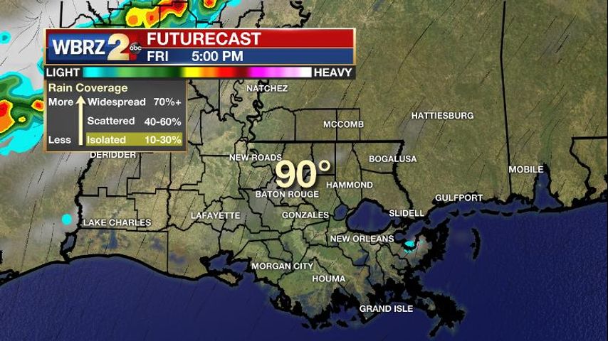
One or two showers still managed to pop in a warm, humid summer air mass on Thursday afternoon. However, it was very different from the multiple round, near washouts experienced last Friday through Wednesday. Similar conditions are expected tomorrow.
The Next 24 Hours: Overnight will be partly cloudy and muggy with light winds and low temperatures in the mid 70s. Aside from a stray afternoon shower, Friday will work out to be dry for most. The consequence is hotter temperatures; highs will top out near 92 degrees with southwest winds of 5 – 10mph. A squall line that develops northwest of the local area may hold together and blow in during the early evening hours. If it maintains, some downpours and gusty winds could arrive near dusk—especially in northern and western parishes and counties.
The Long Term Trend: Over the weekend, a weak cold front will come into the region and serve as a focus for scattered showers and storms—some could bring downpours, frequent lightning and gusty wind. The cold front will slowly erode as it parks over central Louisiana and Mississippi. As this occurs, rain coverage will decrease from scattered on Saturday to isolated on Monday. A second front will try to push south and into the Capital Area around the middle of next week. There are some signs that this one could make it to the coast, therefore slightly decreasing dew points (humidity) and low temperatures for a day or two. No major changes, but maybe lows will be in the lower versus middle 70s while highs stay in the low 90s.
BREAKING: Hurricane Hunters find 75mph+ winds in #Isaias -- now a hurricane. You may see some amendments to the strength forecast as it approaches the U.S. but it still poses no threat to the central Gulf Coast --> https://t.co/1RV22NBAGL https://t.co/BULdmFSty6
— Josh Eachus (@DrJoshWX) July 31, 2020
The Tropics: As of 10pm Thursday, Hurricane Isaias was about 200 miles southeast of the Bahamas with maximum winds of 80mph and moving to the northwest at 18mph. The storm is expected to continue on this path but slow down as it approaches southeastern Florida on Saturday. Warnings have been issued for the Bahamas and Watches are up from Ocean Reef to Sebastien Inlet, Florida. Fresh off the African Coast, showers and thunderstorms associated with a small area of low pressure have become better organized over the last 24 hours. Thanks to favorable conditions, the National Hurricane Center gives this system a 40 percent chance of formation over the next five days.
The Explanation: A warmer, drier atmosphere will result in only isolated showers and storms through Friday afternoon. A positively tilted longwave trough will slowly move from the Lower Midwest to central Gulf Coast Friday night through Monday. Along an associated weak cold front, a squall line is expected to develop northwest of the area on Friday and race off to the southeast. Conditions favor maintenance of this line and it could arrive in southeast Louisiana and southwest Mississippi on Friday evening before falling apart overnight. Northern and western locations could experience some brief downpours and gusty winds if it holds together. Once the front arrives locally, it will be decaying but in combination with the associated upper level trough, there will be an impetus for scattered to widespread showers and thunderstorms—especially Saturday and Sunday. Compared to the soaking conditions of the last week, the atmosphere will be a bit drier this weekend, which will allow some storms to produce frequent lightning and gusty wind. This is because as dry air is pulled into a storm cloud, rapid cooling occurs. Cooler air is denser and therefore quickly falls to the surface in what is known as a downdraft. And even though drier, this is still a summer air mass, so downpours remain possible as well. In addition to providing the next round of active weather, the front and trough will likely combine with an upper level ridge over Bermuda to funnel Tropical Storm Isaias northward around Florida and away from the central Gulf Coast. That trough may be slow to break east until the middle of next week. Some forecast models suggest that an embedded wave diving down the backside of the trough could drive a second cold front a little farther south, perhaps dropping local dew points and low temperatures for 24-48 hours next Wednesday to Friday. It would be a meager change, but we take what we can get in August.
--Josh
The WBRZ Weather Team is here for you, on every platform. Your weather updates can be found on News 2, wbrz.com, and the WBRZ WX App on your Apple or Android device. Follow WBRZ Weather on Facebook and Twitter for even more weather updates while you are on the go.
"front" - Google News
July 31, 2020 at 05:56AM
https://ift.tt/2BLlhdR
Scattered storms to return as weak front arrives this weekend - WBRZ
"front" - Google News
https://ift.tt/3aZh1mr
https://ift.tt/3b2xvu5
No comments:
Post a Comment