Aspen middle and high school students now are set to start in-person classes Oct. 26, which marks the beginning of the second quarter.
Reopening the schools the last week of October dovetails with the two schools’ quarterly system and will smoothen the transition from remote learning to in-person classes, Superintendent David Baugh said Wednesday.
The opening date is three weeks later than what was established in a plan unveiled to Aspen School District’s board of education at its Sept. 21 meeting. The middle school had Oct. 5 marked to reopen, and the high school Oct. 19.
“What we were going to do is completely reshuffle the deck the last three weeks of the quarter and start over in the second quarter,” Baugh said. “What makes sense educationally was to keep things intact and make the changes at the end of the quarter.”
Middle and high school students will attend classes using a hybrid model; in other words, pupils with surnames starting with A through K will go class for a week starting Oct. 26.
The other cohorts — M through Z — would take class remotely that week and start in-person class the week of Nov. 2. Cohorts at both schools would alternate weeks under the hybrid system.
“We may have to make some micro-adjustments if our classes are uneven,” AMS Principal Elizabeth Meador said during a virtual discussion with the middle school community Wednesday.
Elementary school students, who began attending class through a hybrid system Sept. 8, also will see changes Oct. 26.
The biggest change will be moving all elementary school classes to the elementary building; students have been spread out over the campus’ three buildings since school began. They also will continue attending class through a hybrid model where cohorts attend class in-person on Mondays and Tuesdays or Thursdays and Fridays, while Wednesdays are set aside for teacher planning.
Baugh said the extra time to open the upper schools also allows for the upgrade of the elementary school’s HVAC system to improve the air quality.
At the middle school virtual conference, its principal and assistant principal, as well as its psychologist, nurse and the district’s information technology and transportation directors filled in the community on the nuances of getting in-person class started during the health crisis.
That starts with getting students on the buses and to school. Classes will start at 9 a.m. at the middle and high schools, allowing about an hour’s time to clean and disinfect the buses after having toted the elementary kids to the campus.
Middle school teachers of world language and exploration classes will teach virtually instead of directly in class, because “they are in high contact with students across the day. They see hundreds of kids,” said Assistant Principal Jayson Thomas.
If the middle and high schools stay true to their newly scheduled opening date, students will have returned to on-campus learning for the first time since schools closed in March because of the health pandemic.
COVID-19 trends will dictate the schools’ hybrid opening and eventually whether it will expand to full access.
If the county’s Coronameter stays in either the blue or yellow zones — comfortable and cautious, respectively — the schools will be able to open Oct. 26.
Pitkin County was in the yellow zone Wednesday.
“We’re still in yellow and we’re hopeful that it’s going to start dropping off but the trend for the last four weeks is slowing bumping up, so that’s really a problem for us,” Baugh said.
Elementary school health protocols have included parents completing a symptom tracker each morning before their child goes to school. The same approach will take place at the middle and high schools.
“We do want you at this time to fill out the symptom checker each morning before school so that we can see how you all feeling, and it’s a reminder to not come to school if you’re not feeling well or have any of those symptoms,” said middle school nurse Elise Dreher.
Students at all three schools also have the option to continue remote learning during the pandemic.
The City of Portland said Wednesday it will fine the owners of a painting contractor $20,000 for allegedly creating a “front company” to qualify as a woman-owned business. The city is accusing the business, Portland Coatings, of receiving more than $1 million in contracts while falsely claiming to be owned by a woman.
Portland had been investigating Terezia Nyland and her husband, Michael, since 2017, after an unspecified tip to the city’s ombudsman office. The city said Portland Coatings' address is actually the loading dock for a business Michael Nyland owns, Williamsen & Bleid.
In addition to the $20,000 fine, the city suspended the Nylands' eligibility to do business for the city for three years. The Nylands' lawyer said Tuesday they plan to challenge the city’s findings.
“Terezia Nyland is, and has always been, Portland Coatings' majority shareholder and chief executive,” attorney Matthew Colley wrote in an email. “She and her husband have done nothing wrong, and they will be vindicated in the appeals process. Portland Coatings' certification with the State of Oregon is current and has been renewed every year since 2011, when certification was first granted.”
This is the first time Portland enforced a 2015 state law that gives the city the authority to investigate whether businesses qualify for public contracts that give preference to “disadvantaged businesses.” That category includes businesses owned by Blacks, Hispanics, Native Americans, women and others who have historically had less access to lucrative government contracts.
Former Oregonian reporter Tony Green investigated the case for the city ombudsman’s office, which is a division of the city auditor. Green left the paper in 2008.
Last month, Friedman contributed to a city audit that found Portland’s efforts to reduce disparities in city construction contracting had some effect, “but they also suffered from design flaws and mismanagement, and were vulnerable to gamesmanship.”
"front" - Google News
October 01, 2020 at 01:05AM
https://ift.tt/30oqEZn
Portland fines contractors for allegedly creating ‘front company’ to certify as woman-owned business - OregonLive
"front" - Google News
https://ift.tt/3aZh1mr
https://ift.tt/3b2xvu5
If today was a bit too cold for you, we have a slight warm up on the way Thursday.
Sunshine will once again be plentiful as highs warm to the low 80’s. We will also see a small uptick in our humidity from today, but it shouldn’t be too noticeable.
This Thursday warm up will be ahead of yet another cold front that is headed our way. This will be a dry front, so no rain is expected, but it will bring our temperatures back in check.
With this front our lows Friday into Saturday are forecast to fall into the upper 40’s once again.
The weekend will bring even more sunshine, low humidity, and temperatures in the mid and low 70’s.
It will be a pleasant weekend, that will likely continue into next week as well.
Although we are forecasting a miniscule warm up, temperatures across the southeast will be staying below normal for much of the next two weeks. Congrats to everyone who is loving this fall weather!
Along with all that, it is still hurricane season for a while more. An area of activity (the red x) is forecast to strengthen into a tropical cyclone within the next five days.
Another area of storms (the yellow x) is also forecast to move closer to the Caribbean, but within the next 5 days, this system will likely not be a cyclone.
While we don’t know where this system will go once it has formed, we definitely need to keep a close eye on it.
Minimal smoke was seen from the Middle Fork Fire on Monday, but has since increased throughout the week. Courtesy/U.S. Forest Service
STEAMBOAT SPRINGS — After almost four weeks of burning through Mount Zirkel Wilderness Area in the Routt National Forest, the Middle Fork Fire has now surpassed 8,000 acres.
As of Wednesday afternoon, the fire burned 8,037 acres and is 0% contained, according to a report from the U.S. Forest Service.
The fire is burning about 10 miles north of Steamboat Springs, and officials had not ordered any evacuations as of Wednesday.
With warmer and drier weather expected in the next few days, the fire’s incident team expects increased activity, according to its daily incident report.
Jesse McCarty, Forest Service spokesman, said he “would not be surprised” if the fire continued until Routt County receives snow, which is not forecast in the next 10 days.
While the fire is not contained, a portion of the eastern fire perimeter has not spread for over two weeks, according to the report.
About 95 personnel are assigned to the fire, including four helicopters and a fixed-wing airplane to help coordinate aerial operations, the report states.
Portions of the Routt County National Forest are closed including Mount Zirkel Wilderness boundary on the east side, the south side on Newcomb Creek Trail, Continental Divide Trail, the wilderness boundary and Swamp Park Trail, Saddle Trail, Saddle Cut-off and Red Dirt Trail. The west side between National Forest and private lands east of Big Creek from Red Dirt Trailhead to Roaring Fork Trail and the north side along the wilderness boundary. The North Fork Drainage up to The Dome, east to Lost Ranger Peak, Continental Divide Trail and Lost Ranger Trail are also closed. No roads or trailheads are closed.
To reach Alison Berg, call 970-871-4229 or email aberg@SteamboatPilot.com.
Ample sunshine is in the forecast each and every day through at least the end of next week but despite the lack of rainfall, we’re still anticipating some changes to our weather as a few cold fronts move through the area. The first of potentially two cold fronts swings through the area Thursday. Tomorrow’s front will slowly sag through the area and we’ll likely see a bit of a temperature difference depending on what side of the front you’re on. Morning temperatures in the mid-to-upper 50s will warm into the mid-to-upper 70s behind the front around lunch time and should reach the low 80s ahead of the front. The front should be slowly crossing over the Highway 84 corridor around lunch time and should completely clear the area by the late afternoon. Afternoon highs should reach the low-to-mid 80s.
Slightly cooler air takes hold Friday and while temperatures won’t be too cold, you’ll certainly notice a change. Morning temperatures Friday start in the low-to-mid 50s but should warm only into the upper 70s Friday afternoon. We’ll rebound into the low-to-mid 80s this weekend still with lots of sunshine overhead. Another cold front likely moves through the area Sunday. Sunday’s front should drop temperatures briefly into the upper 70s and low 80s Monday before temperatures warm back into the mid 80s for the remainder of the week. Some forecast model data is hinting that Sunday’s front may not reach our area and if it doesn’t, we’ll likely see warmer temperatures in the upper 80s for much of next week.
ARLINGTON, Texas (CBSDFW) – A car struck and killed a pedestrian who was walking in the middle of the 5800 block of the southbound frontage road of U.S. 287 in Arlington.
It happened on September 30 at 12:27 a.m.
The involved driver stopped and remained on scene after the crash and is cooperating with the investigation.
There were no signs of impairment on the driver.
Investigators said they don’t know why the pedestrian was walking on the roadway.
The Tarrant County Medical Examiner’s Office will identify the deceased once next of kin have been notified.
Photo: Contributed Photo / Norwalk Police Department
Photo: Contributed Photo / Norwalk Police Department
Image 1of/1
Caption
Close
Image1of1
Marcus Gaffney
Marcus Gaffney
Photo: Contributed Photo / Norwalk Police Department
Norwalk PD: Bridgeport man sexually assaulted woman in front of children
Back to Gallery
NORWALK — A Bridgeport man sexually assaulted a woman in front of three children, according to police.
Police said an officer on extra-duty assignment was in the area of Strawberry Hill Avenue around 2:45 p.m. on Friday when he saw a man lunge into another person’s car and cause a commotion.
The man, later identified as 36-year-old Marcus Gaffney, allegedly jumped into the person’s car moments after a child was seen getting in the car.
When the officer approached the car, he found Gaffney laying across the lap of the child and the driver of the car, who police said was “hysterical.” There were also two children sitting in the backseat of the car, police said.
The victim later told police that Gaffney, who was unknown to her, had grabbed her breasts and crotch during the incident.
Police spokesperson Lt. Jared Zwickler said the officer tried to remove Gaffney, but he refused to get out and began kicking the officer.
During the struggle, the officer had to disarm Gaffney of a knife, according to Zwickler.
Eventually, with the help of two civilians, Gaffney was arrested. While in custody, Gaffney, who police believe was under the influence of PCP, spit on an officer, according to Zwickler.
Gaffney was charged with third-degree sexual assault, two counts of third-degree assault, third-degree criminal mischief, three counts of risk of injury to a minor and interfering with an officer. He was held on $250,000 bond and given a court date of Dec. 7.
"front" - Google News
September 30, 2020 at 10:15PM
https://ift.tt/3mYKTGK
Norwalk PD: Bridgeport man sexually assaulted woman in front of children - Thehour.com
"front" - Google News
https://ift.tt/3aZh1mr
https://ift.tt/3b2xvu5
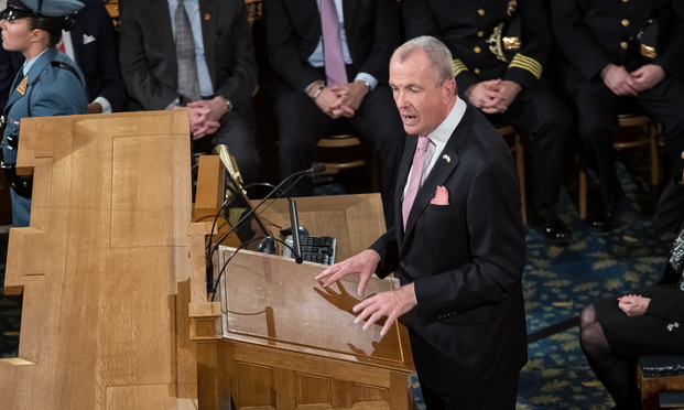
New Jersey Gov. Phil Murphy delivers the “State of the State” address on Jan. 14, 2020.
Gov. Phil Murphy signed a truncated $32.7 billion fiscal year 2020-21 budget on Tuesday, a day ahead of the Sept. 30 deadline to come up with a balanced state budget to fund the next nine months.
AUBURN — A student associated with Auburn Middle School has tested positive for COVID-19, according to Superintendent Connie Brown.
Brown wrote in a letter to parents and staff that it’s possible “that other staff or students came in contact with this individual and therefore may be exposed to the virus.”
Brown wrote that the Maine Center for Disease Control or an Auburn Middle School representative would contact families directly if their student was “identified as a close contact to someone who tested positive.”
Auburn Middle School already had a staff member test positive for COVID-19 earlier in September, though students hadn’t returned to school at the time.
LONG BEACH, Miss. (AP) — An entire middle school in Mississippi is in quarantine after more than a dozen students tested positive for coronavirus.
Long Beach Middle School ordered Tuesday that all students be quarantined for two weeks beginning Wednesday, according to the school’s website. Students will return to the classroom on Oct. 14.
The news comes after 15 students tested positive for the virus, the school said. Another 165 students are under quarantine. In a statement, officials said they made the decision to temporarily shut down the school after 35% of students either tested positive or were exposed to the virus.
ADVERTISEMENT
The Mississippi Department of Health recommends that schools quarantine when 33% of students are positive or exposed.
Since the start of the pandemic, at least one other Mississippi school has had to quarantine all of its students because of a coronavirus outbreak. Biloxi High School sent all of its students home in late August after students were exposed at what State Health Officer Thomas Dobbs described as “unnecessary” social gatherings.
The state health department said Tuesday that Mississippi, with a population of about 3 million, has reported more than 97,000 cases and at least 2,957 deaths from COVID-19 as of Monday evening. That’s an increase of 589 confirmed cases and 36 deaths from numbers reported the day before, with 21 deaths occurring between Sept. 20 and Sept. 28 and identified later using death certificates.
South Floridians will need to keep that umbrella handy for much of the next week thanks to a front that will likely end up stalling over the area starting Wednesday.
We have a front arriving by the afternoon along with scattered showers and thunderstorms. Rain chances will be around 40% as highs push into the upper 80s to near 90. The evening rush could be a little tricky.
The front will then stall across South Florida keeping rain chances high all week and into the weekend. Isolated flooding is certainly possible with the combination of high humidity and the front lingering.
Highs will remain in the 80s this week with a noticeable breeze by the weekend.
Stay up to date with NBC 6 First Alert Weather and South Florida's most powerful radar First Alert Doppler 6000 by downloading the NBC 6 app for iOS or Android.
"front" - Google News
September 30, 2020 at 07:03PM
https://ift.tt/348YliR
Front Likely to Stall, Bring Wet Weather to South Florida Starting Wednesday - NBC 6 South Florida
"front" - Google News
https://ift.tt/3aZh1mr
https://ift.tt/3b2xvu5
A woman was found shot to death in a car outside a church in Dacula.
DACULA, Ga. - A woman was gunned down early Wednesday morning in unincorporated Dacula. Police found the victim inside a car located in the Christ the King Church parking lot, but they think she was actually shot at a home across the street.
Officers responded around 3 a.m. to the 200 block of Rabbit Hill Road. The woman died at the scene. Investigators don't know if she was shot in the car or the house, but think she drove across the street to the church lot where she was found.
Police have yet to ID her. They also don't know how old she is and if she lived in the home where the shooting took place.
There were a number of people at the house when officers arrived. They are all being called witnesses as detectives talk to them trying to figure out what led up to the shooting and who pulled the trigger.
This story is breaking. Check back for details. If you have additional information, pictures, or video email newstipsatlanta@foxtv.com.
After a night out with her children in August, La’Condria Burley returned home to find the locks on her door changed and their belongings in an alley beside the three-family home where they live. Despite a state moratorium on evictions, her landlord said she had to leave because rent hadn’t been paid in three months, Burley said.
A cross vandalized at St. Vincent de Paul Church a year ago was replaced with a new, more durable one this week after the church raised thousands of dollars for the cause. Plus, the Town of Weehawken has removed the face of a Native American from its stadium scoreboard perched above the Lincoln Tunnel.
Also, fans and parents will not be allowed to attend athletic events for Jersey City’s public high schools during the coronavirus pandemic, according to two athletic directors within the district.
In Sports, the Tampa Bay Lightning won their second Stanley Cup Monday night. Plus, the Tennessee Titans suspended in-person activities through Friday after the NFL says three Titans players and five other personnel tested positive for the coronavirus, becoming the first COVID-19 outbreak of the NFL season in Week 4.
ORLANDO, Fla. (WESH) – A dashcam video shows a driver on a highway near Orlando firing at another car through his own windshield.
The intense moment was posted on YouTube by driver Marco Mazzetta, who said he was trying to defend himself because he believes he or the passenger in his car were in danger of being shot.
The Florida Highway Patrol said it shows how dangerous it can be to argue with other drivers on the highway.
“You don’t know the mindset of the other driver that you may accidentally get involved with some type of situation,” said Kim Montes with FHP. “A lot of people carry weapons in their cars, and this could have really escalated to somebody getting shot, somebody getting killed.”
The in-car video shows another car driving aggressively
At one point, it gets extremely close to Mazzetta’s truck.
He said he tapped the brakes and the other car bumped him from behind. It then sped around him.
Later, the other driver slowed down, pulled out a gun and pointed it at him, Mazzetta said.
That’s when Mazzetta said he took out his own gun and fired because he feared the other man was going to shoot him.
“I’m not a fan of guns; I’m a fan of not getting shot,” Mazzetta said via text.
“I know this video doesn’t capture my smartest moments but I hope any idiot criminal with a gun watching thinks twice before loading, brandishing and aiming their firearm at someone over a traffic infraction.”
Mazzetta said he reported the incident to the Orange County Sheriff’s Office.
Copyright 2020 WESH via CNN Newsource. All rights reserved.
Have a question for Lennard? Please email him at veloqna@comcast.net to be included in Technical FAQ.
Dear Lennard,
Any idea what happened with Chloé Dygert’s bike for it to shake so much that she crashed out of worlds like that?
– Brett
Dear Brett,
What a heart-breaking crash! Dygert had clearly put in the work through the pandemic and during the first half of the course required to win that race. She was so far ahead at the time split that it looked like she just had to roll it steady, and she would win, as Christian Vande Velde had just said on the live NBC coverage.
Team general manager Nicola Cranmer told me, “Yes, that was a bad day for sure. She is doing pretty well all things considered. There was no equipment or mechanical errors. Chloé is a fierce competitor and pushed the limits.”
When I first saw it, I thought it was a front tire problem—either a rolled tubular or a burped tubeless tire, and, after watching the crash in slow motion, I no longer think that. I wondered about a tubeless burp because Dygert’s team had sent out a pre-race press release showing her with a custom-painted Felt DA time trial bike with world champion stripes, seen in revolving photos on the team web site. it said the bike is equipped with 700c x 25mm Kenda Valkyrie TLR Pro tires. The bike she was riding and the one on the roof of the USA Cycling car were black, however, and I have no idea if she was riding tubeless tires; riders on teams sponsored by clincher tire companies often race on tubulars, anyway.
I’ve watched the crash in quarter-speed slow motion many times to evaluate what role her equipment played in this. Slowing the third (slo-mo) replay on this video by three quarters is really slow.
I think it’s abundantly clear that Dygert would have made the corner if her bike had not wobbled. Is it to be expected that a bike would wobble simply by cornering at high speed, hands on the aero bars, weight forward on the bike? I found two YouTube videos with thousands of views by guys “analyzing” the crash and who attribute it entirely to that; they claim a bike will always get a speed wobble at high speed in a corner when in the aero position. Well, having witnessed in person David Zabriskie rip around downhill traffic circles at incredible speed without deviating from the aero position when winning the 2005 Tour de France prologue from Fromentine to Noirmoutier-en-l’Île, I don’t believe that. His Cervelo time trial bike showed no signs of speed wobble. That’s not to say that some time trial bikes may shimmy under those conditions, but it’s not a given. Dygert has ridden a lot of miles at high speed on Felt time trial bikes and pursuit bikes without coming out of the aero position, and I doubt she would enter a corner like that at speed if she had any fears about the bike’s stability.
I endeavored to ascertain whether each one of the 10 wobbles I saw corresponds to one revolution of her wheel, thus ruling in or out the possibility of a dislodged tire. I attempted to discern the distance between the first wobble and the point of impact with the guardrail. Each revolution of her wheel with a 25C tire would be 2.12 meters, so 10 revolutions would be 21.2 meters, or 70 feet. I count 20 green pads attached to the guardrail. I don’t know the dimensions of each pad. They look similar to me to a 4’ X 8’ (48” X 96”) sheet of plywood, so, given the metric system in Italy, perhaps they are 1m X 2m (39” X 79”) in size.
She was riding a 54cm Felt DA time trial bike. Although the geometry detail numbers seem to be missing on that page, we can estimate the bike’s wheelbase to be 1000mm and the tire diameter (700 X 25C) to be 675mm. So, the total length of the bike is about 1675mm (66”). Due to the angle of the camera being behind her, it’s unfortunately hard to tell how long those pads are relative to the length of her bike.
I count 10 abrupt back-and-forth wobbles on her trajectory before she hits the guardrail, the first one being about even with the round blue sign with the angled white arrow on it. The wobbles appear to start at about the fourth pad, and she hits the guardrail perhaps four pad-lengths beyond the last pad, so she gets in 10 wobbles over the distance of perhaps 20 pads. Rather than being two meters long as I guessed above, if the pads are instead only one meter in length (about the length of her bike’s wheelbase), then that is about 20 meters, or very similar to the 21.2m her bike travels in 10 wheel revolutions, indicating that each wobble corresponds to one wheel revolution. On the other hand, if the pads are instead each 2m in length, then she traveled more like 40m (131 feet) over the 10 wobbles, so each wobble corresponds to around two revolutions of her wheel and eliminates the possibility of it being a tire issue. Another way to look at it is that she does all 10 wobbles within a span of 3 seconds. If she were going 30mph, then 3 sec x 30 miles/hr x 5280 feet/mi x 1hr/60min x 1min/60s = 132 feet.
She does not appear to have a front flat; each time the wobble re-centers her, she seems to be atop an inflated tire. Furthermore, a rolled tubular would have kept rolling off further with each jerk of the front wheel, and a burped tubeless tire or dislodged bead would have immediately deflated; in either case, she would have slid off into the pads, rather than fighting for control and riding past all of the pads. Both methods of determining the distance over which she was in the speed wobble indicate that it’s too far for it to be one wobble per revolution, so I don’t think it has anything to do with the tire.
I'm eagerly refreshing my feed for updates on Chloe, and I see a lot of conjecture about the cause…my 2 cents: she did not have her hand on the rear brake, but kept it in the skis. Trying to save an over-cooked corner with only the front brake will cause that wobble.
Chad Haga has a theory that she hit the front brake, causing the speed wobble. I can’t be sure that she did that. Clearly, her right hand stayed on the aero bar (and away from the brake lever) when she hit the guardrail. When she starts going over the rail, it is clear that her left hand is not on the aero bar, and I cannot be certain at what point it came off of the aero bar.
Right when she is about to pass the round, blue sign with the white arrow on it, her left shoulder lifts, perhaps to move her left hand to the base bars. If it did go to the base bars (and the lever) in the corner, then, assuming that her bike is not set up “moto-style”, she might have indeed touched the front brake with it. That could explain some of why her weight is being alternately thrown forward and then back onto the saddle as well as the initial break in front-wheel traction.
An extreme example of a “tank-slapper” high-speed wobble.
I think it was a “tank-slapper”, where, once the front wheel breaks traction, a chain reaction happens, because the fork oversteers past the desired line, starting the process over and over again by repeatedly breaking front tire traction, causing the bike to jerk back and forth. This was exacerbated by her right arm being on the aero bar; the added momentum of her arm out there with so much of her weight concentrated on the bar added to the momentum already swinging the fork and wheel back and forth beyond the line of her turn, breaking front tire traction each time. And with her right arm out there, she had no way to slow the rear wheel. Especially in a turn at high speed, it is very difficult to regain control from this before running out of road, at the apex of the turn.
How the front tire initially lost traction remains a question. Combined with entering the turn too fast, it may have been by Dygert hitting the front brake too hard or by a bump at the beginning of the turn, or both. It looked in the live coverage as though both Victor Campenaerts and Tom Dumoulin both experienced wobbles in the same corner, and a bump might help explain that coincidence.
My guess is that, had Dygert sat up and put both hands on the base bars before that turn, she would have made it through just fine. First of all, the air braking caused by her body coming up might have scrubbed off enough speed that she would not have needed to brake. And, had she needed to slow down more to stay on her line, she could have applied the rear brake to do so. ― Lennard
LEXINGTON, Ky. (WKYT) - The feel on the other side of this front is quite different. Almost jarring for some of you.
Temperatures will end up down around 10-15 degrees for highs this afternoon. That is how intense the cold air behind this front is for us. This first front of the week did the hard work. It paved a road for the next one to pass through the region with very few issues. It will have another cold shot of air, but not as big of a drop. It looks like a mainly dry passage.
After the two cold fronts are a distant memory, we find some of the coldest air since May trying to run the show for us. Daytime highs will likely come in around the upper-50s and low-60s for a few days. There is a chance that overnight lows will drop to the mid and upper 30s. We could flirt with frost potential, but we still need a few other elements to come together so that it actually happens. As of this moment, I am not sure we will dip to that level for long enough to get it to develop.
It is another Tuesday, and every day we move forward is a day closer to a return to our ordinary world. We are nearly there! Take care of each other; we’ve got this!
A strong cold front begins working through our area today leading to widespread showers and even a few storms. While we do NOT expect widespread severe weather or flooding, isolated strong storms could lead to localized flooding into Tuesday night. The high for today already took place just after midnight we’ll see temperatures fall into the 60s this afternoon. Then a second cold front brings much cooler weather by the weekend. Behind the second front we’ll also find drier air meaning more sunshine.
A line of showers and storms move through the region today.(WDBJ)
TUESDAY
Cloudy skies are expected through the day with rain and drizzle early in the day, increasing in coverage throughout the afternoon from west to east. Total rainfall by the time the front exits late Tuesday night and early Wednesday morning will range between 1″ and 2″. Highest totals are expected along/east of the Blue Ridge Parkway. Any flash flooding would be isolated. No flood alerts have been issued. As far as the severe storm risk, one or two storms may produce gusty wind
TUESDAY HIGHLIGHTS
Drizzle or stray showers through lunchtime
Several rounds of rain and storms Tuesday afternoon
Highest chance/coverage during the afternoon & evening
Rainfall: 0.50-2″ with localized downpours
Low severe risk, and elevated flood risk east of the Blue Ridge Parkway
A strong front will trigger showers and storms across the region today.(WDBJ)
LATE-WEEK COOL DOWN
Wednesday and Thursday will return to the upper 60s and be breezy at times, especially Wednesday. The second cold front will arrive mostly dry Friday and will bring a notable cool down for the weekend.
By the end of the week, a second cold front will bring high temperatures well below average, reaching the low/mid 60s over the weekend. Overnight lows will slip to the upper 30s to low 40s for the first weekend of October.
A second front will bring another shot of chilly air into the region.(WDBJ)
TROPICAL OUTLOOK
Most of the tropics are quiet right now, but we do have one area that has a 50% chance of development in the next 5 days near the Yucatan Peninsula. You can get the latest tropical outlook and track details in our Hurricane Center.
HOUSTON, Texas (KTRK) -- Our first fall front is here, and it will bring us our coolest mornings since May 11th.
As the north wind settles down overnight, temperatures will drop into the 50s everywhere except near the coast where the warm Gulf waters will keep lows in the 60s.
Once the sun comes up, temperatures will start to warm under a clear sky. It'll be sunny and breezy under that blue sky with highs only in the upper 70s Tuesday afternoon. Just remember that the front blew in some high levels of ragweed and elm tree pollen, so you might be sneezing and sniffling while enjoying the fall-fresh air.
Our coolest temperatures behind the front will occur around sunrise Wednesday with lows in the lower and middle 50s. It will warm back into the 80s both Wednesday and Thursday, so if you wear a sweater in the morning, you might need to shed that warm layer by the afternoon. A weaker front arriving Thursday night will reinforce the nice air, giving us more nice weather into the weekend.
The sticky Gulf breeze is back by Sunday, pushing temperatures back to average for early October as we go into next week. That means highs in the mid 80s and lows in the mid 60s.
That issue - the most bitterly partisan of all political battles – is a Supreme Court nomination fight, and it’s coming with just five weeks to go until Election Day.
Preparations take place for the first presidential debate in the Sheila and Eric Samson Pavilion, Monday, Sept. 28, 2020, in Cleveland. The first debate between President Donald Trump and Democratic presidential candidate, former Vice President Joe Biden is scheduled to take place Tuesday, Sept. 29. (AP Photo/Patrick Semansky)
The former vice president’s urging the GOP controlled Senate to hold off on any vote on the president’s nominee – conservative federal appeals court judge Amy Coney Barrett – until the winner of the presidential election’s determined.
"The Senate has to stand strong for our democracy," Biden emphasized Sunday. And he urged senators to "take a step back from the brink," and that now “is a time to de-escalate."
The president is barreling forward, telling "Fox & Friends" co-host Pete Hegseth in an interview on Sunday that he thinks Barrett could be confirmed ahead of Election Day on Nov. 3. Trump argued there’s "tremendous amount of time” from the kick off of the Senate Judiciary Committee’s confirmation hearings on Oct. 12 until the election.
"I think we could have it done easily before the election," Trump predicted.
The Supreme Court confirmation showdown’s one of the 6 topics chosen for the first debate by the moderator, “Fox News Sunday” anchor Chris Wallace.
Since the death of liberal leaning Supreme Court Justice Ruth Bader Ginsburg a week and a half ago, the former vice president’s spotlighted the threat to the survival of the Affordable Care Act – the nation’s health care law best known as Obamacare – warning that Barrett would likely vote to eliminate the landmark measure in a case coming to the high court a week after the November election.
“Absolutely. It’s health care,” stressed veteran Democratic consultant and Fox News contributor Donna Brazile. “The Republicans have tried to gut and destroy the ACA for over nine and a half years and this is their first real shot at doing that with Judge Barrett. Biden has to carefully explain to the American people why now, and why Judge Barrett is a threat to the Affordable Care Act.”
“The vice president has to talk about what’s at stake. Everything is at stake, from voting rights to gay rights to workers’ rights to abortion rights,” spotlighted Brazile, who managed Vice President Al Gore’s 2000 presidential campaign and who twice served as interim chair of the Democratic National Committee over the past decade.
Longtime GOP strategist and Fox News contributor Karl Rove noted that if Biden targets the president for pushing forward with the nomination so close to the election, Trump “needs to defend … because the president of the United States has a constitutional authority to nominate and the Senate has the right to give its advise and consent or not. There’s no time limit on that. We have one president at a time.”
Brazile acknowledged, “Yes, we know the president has a right to appoint and the Senate has a right to verify. We understand the constitutional issues.” But she emphasized that the question for Biden to spotlight “is why rush this through so close to the election?”
Rove, the mastermind behind both of President George W. Bush’s presidential election victories, said that Trump “wants to do two things. He wants to say ‘I picked somebody who will strictly interpret the constitution and the laws of the United States as written and will not be a legislator in robes.’ It’s a very popular theme and it cuts across party lines. And second of all, he can extoll her background, which is exemplary.”
And if Trump has the time, Rove suggested that the president attack Biden for not releasing his own list of potential high court nominees, as Trump did in the 2016 election and again this month. Rove offered that the president should look at Biden and argue that "the reason you haven’t given us a list is because the American people would figure out they’re all judicial activists on the left of American politics who will use the position on the court to legislate from the bench rather than strictly apply the law.”
Nicondra began her broadcasting career in 1999 with WAKA, the CBS affiliate, in Montgomery, AL. She spent almost six years in Alabama as weekend, then later, morning meteorologist. She is a proud member of the American Meteorological Society, The National Weather Association and The National Association of Black Journalists.
HOUSTON, Texas (KTRK) -- The cool front moved through Southeast Texas this morning bringing gusty north winds and cooler air. Cool air will continue to filter in this evening dropping temperatures into the 50s to start off your Tuesday! This cold front will usher in several days of pleasant fall weather for all of Southeast Texas.
Winds are expected to be gusty throughout the afternoon today with winds gusting between 30-40 mph at times. A Wind Advisory is in effect until 9 pm tonight.
As the winds settle down a bit Monday night, temperatures will fall into the 50s by sunrise Tuesday. It'll be sunny and breezy under that blue sky with highs only in the 70s Tuesday afternoon. Our coolest temperatures behind the front will occur around sunrise Wednesday with lows in the lower and middle 50s. It will warm back into the 80s both Wednesday and Thursday. A weaker front arriving Thursday night will reinforce the nice air, giving us more nice weather into the weekend. Enjoy!
The first strong front of the fall season is set to arrive in Florida this week, with widespread showers and thunderstorms marking its arrival and an autumn-like cooldown likely in its wake.
Moisture has already been on the rebound across much of the state ahead of the front, which was evident by how numerous and long-lasting the downpours were on Sunday. Wet weather is expected again Monday across most of Florida as a weak warm front lifts north. This will be followed by the arrival of a strong cold front Tuesday and Wednesday, producing another widespread round of showers and thunderstorms ahead of it.
Higher levels of instability and deep amounts of atmospheric moisture are forecast to create an environment favorable for the strong storms across the northern third of the state, including the Floridan Panhandle, Tuesday. The strongest cells would be capable of producing heavy rainfall, gusty winds, excessive lightning, and isolated tornadoes. Localized flash flooding will also be possible, especially across already saturated soil in the Florida Panhandle. Showers and thunderstorms are then likely in portions of central and south Florida when the front arrives in these locations Wednesday, with locally heavy rain and gusty winds also possible.
Many Floridians will find a positive side to this approaching cold front, and that is the return of fall-like temperatures and a drier weather pattern that moves in behind it. Daytime highs will only range from the 70s across the Florida Panhandle and portions of North Florida to the lower 80s in areas farther south across Central Florida. Low temperatures could dip into the 50s and 60s across these areas Wednesday and Thursday mornings, and the below-average temperatures and dry conditions are expected to continue through the end of the week.
While the northern two-thirds of The Sunshine State begin to dry out, the front may have trouble clearing South Florida. As a result, a wet pattern could continue in cities like Key West, Naples and Miami through the rest of the week and into the weekend. Weather models are indicating that the cold front will stall near line from Fort Myers to Fort Pierce, allowing the tropical moisture to remain in place and scattered showers and thunderstorms to continue.
This week’s cold front is expected to be the strongest of the season so far, and it would be considered earlier than normal in most Florida cities. For example, a front of this strength wouldn’t typically move through Central Florida until sometime in mid-October.
Even though a period of cooler and drier weather is expected later this week across most of the state, it should be noted that the 2020 Atlantic hurricane season is not over. Tropical storms can and do often develop along stalled fronts of this nature in the Gulf of Mexico or northern Caribbean Sea during the month of October. However, at the present time, there are no tropical threats looming for at least the next five days.
Good Monday, everyone. A potent fall cold front is crossing the state today and it’s bringing a major temperature change. In the process, showers and storms are sweeping across the state to go along with very gusty winds. Even colder air will then follow this up later in the week.
Let’s kick things off with the action along the front. Temps ahead of our boundary will spike to near 80 and that creates some instability. As the front moves into this air across the eastern half of the state, some of the storms may become strong.
The Storm Prediction Center has this area in a low-end risk for severe storms:
Damaging wind will be the primary player with this line of showers and storms. Even without true severe storms, winds will be very gusty and may reach 40mph at times along the front. The NAM wind gust forecast for Monday shows this well:
I mentioned the temps ahead of this front and how they warm. Some areas will flirt with 80 at the same time areas behind the front are dropping into the 50s. This front means business as it passes over your house:
Some may see a 25-30 degree drop in just an hour or two.
Leftover showers will carry us into Tuesday across eastern Kentucky with low clouds being tough to break into the rest of the region. This means Tuesday’s highs likely stay in the 50s east and only 60-65 for the rest of the state:
From there, we watch another front drop in from the northwest as we open October on Thursday. That has even colder air behind it and we may even see some Friday showers coming all the way from Lake Michigan:
Highs Friday and Saturday will likely stay in the 50s with lows that can reach the frosty 30s.
Another system is going to dig into the Ohio Valley by Sunday and Monday and that could bring additional chilly showers:
That can actually get darn chilly in terms of high temps.
I leave you with your storm tracking toys for the day:
HOUSTON, Texas (KTRK) -- The moment Houstonians wait for all summer long is almost here: The first fall front! Temperatures will stay on the mild and sticky side through the night until the front blast through with a brisk north wind.
Along the front we could see some scattered showers and isolated storms, with the front likely making its way through Houston a little after sunrise.
The front should clear Galveston well before noon, ushering in several days of pleasant fall weather for all of Southeast Texas. Temperatures will dip into the 60s for a few hours behind the front then rebound into the upper 70s as the sun comes out in the afternoon. Expect those north winds to gust up between 30-40 mph at times.
As the winds settle down a bit Monday night, temperatures will fall into the 50s by sunrise Tuesday. It'll be sunny and breezy under that blue sky with highs only in the 70s. Our coolest temperatures behind the front will occur around sunrise Wednesday with lows in the lower and middle 50s. It will warm back into the 80s both Wednesday and Thursday, then a weaker front arriving Thursday night will reinforce the nice air, giving us more nice weather into the weekend. Enjoy! RADAR MAPS: Southeast Texas Houston Harris County Galveston County
"front" - Google News
September 28, 2020 at 12:00PM
https://ift.tt/347Kjhp
Houston weather: Monday morning's cool front ushers in week of fall weather - KTRK-TV
"front" - Google News
https://ift.tt/3aZh1mr
https://ift.tt/3b2xvu5
The first strong front of the fall season is set to arrive in Florida this week, with widespread showers and thunderstorms marking its arrival and an autumn-like cool down likely in its wake.
Moisture has already been on the rebound across much of the state ahead of the front, which was evident by how numerous and long-lasting the downpours were on Sunday. Wet weather is expected again Monday across most of Florida as a weak warm front lifts north. This will be followed by the arrival of a strong cold front Tuesday and Wednesday, producing another widespread round of showers and thunderstorms ahead of it.
Higher levels of instability and deep amounts of atmospheric moisture are forecast to create an environment favorable for the strong storms across the northern third of the state, including the Floridan Panhandle, Tuesday. The strongest cells would be capable of producing heavy rainfall, gusty winds, excessive lightning, and isolated tornadoes. Localized flash flooding will also be possible, especially across already saturated soil in the Florida Panhandle. Showers and thunderstorms are then likely in portions of central and south Florida when the front arrives in these locations Wednesday, with locally heavy rain and gusty winds also possible.
Many Floridians will find a positive side to this approaching cold front, and that is the return of fall-like temperatures and a drier weather pattern that moves in behind it. Daytime highs will only range from the 70s across the Florida Panhandle and portions of North Florida to the lower 80s in areas farther south across Central Florida. Low temperatures could dip into the 50s and 60s across these areas Wednesday and Thursday mornings, and the below-average temperatures and dry conditions are expected to continue through the end of the week.
While the northern two-thirds of The Sunshine State begin to dry out, the front may have trouble clearing South Florida. As a result, a wet pattern could continue in cities like Key West, Naples and Miami through the rest of the week and into the weekend. Weather models are indicating that the cold front will stall near line from Fort Myers to Fort Pierce, allowing the tropical moisture to remain in place and scattered showers and thunderstorms to continue.
This week's cold front is expected to be the strongest of the season so far, and it would be considered earlier than normal in most Florida cities. For example, a front of this strength wouldn't typically move through Central Florida until sometime in mid-October.
Even though a period of cooler and drier weather is expected later this week across most of the state, it should be noted that the 2020 Atlantic hurricane season is not over. Tropical storms can and do often develop along stalled fronts of this nature in the Gulf of Mexico or northern Caribbean Sea during the month of October. However, at the present time, there are no tropical threats looming for at least the next five days.
Copyright 2020 WUFT 89.1. To see more, visit WUFT 89.1.


 New Jersey Gov. Phil Murphy delivers the “State of the State” address on Jan. 14, 2020.


9(MDA4MjgzNjQ1MDEzMTc5MzUzNzIxNjNmZg004))

Invalid username/password.
Please check your email to confirm and complete your registration.
Use the form below to reset your password. When you've submitted your account email, we will send an email with a reset code.